19th June 2026
Publication Information
Download Publication
- 723 KB PDF
- 19th June 2026
Stay Informed
Get email updates about new ACCR research and shareholder advocacy on specific topics of interest to you.
Sign UpThis communication is for informational purposes only and does not constitute financial, legal, or professional advice. ACCR does not hold an Australian Financial Services Licence and does not provide financial product advice. The purpose of this communication is not to provide financial product advice. Please read the terms and conditions attached to the use of this site.
Dr Sophie Lewis, Chief Scientist - Engagement
Throughout 2026, there have been increasing reports about a possible El Niño developing. Meteorological organisations have now declared that the 2026 El Niño event has begun.
The months of speculation about an emerging El Niño have not simply been an academic discussion for meteorologists – the 2026 El Niño has formed on top of a long-term warming trend, and its effects are likely to be amplified, with significant implications for weather, the environment, and the economy over the coming months.
The El Niño–Southern Oscillation, or ENSO, is a naturally occurring climatic cycle. It is driven by interactions between the ocean and atmosphere in the tropical Pacific Ocean and shifts between three phases: El Niño, neutral, and La Niña.
To understand El Niño, it helps to start with “normal” conditions. Typically, strong trade winds blow from east to west along the equator. These winds push warm surface water away from South America toward Southeast Asia and northern Australia. As that warm water moves west, colder water rises from the deep ocean near South America – a process known as upwelling.
During El Niño, the easterly trade winds weaken. When that happens, warm water in the western Pacific begins to drift back toward the central and eastern Pacific. This shift in ocean temperatures might not sound like much, but it has enormous consequences.
The warmer ocean releases heat into the atmosphere, which disrupts wind patterns and changes the way storms move around the planet. El Niño tends to redistribute heat across the planet, which can lead to record-breaking temperatures, shifts in storm activity, and disruptions to food production. In some regions, it can suppress rainfall; in others, it can trigger intense downpours and flooding.
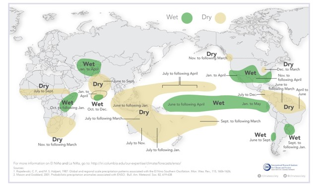
El Niño is known to affect weather around the world. The changes shown in rainfall patterns are more likely during El Niño, but not certain. Source: International Research Institute for Climate and Society.
To bring this to life, let’s look at 2014 when the Pacific began to warm, pointing toward a developing El Niño.
During that year, sea surface temperatures in parts of the tropical Pacific rose above average, and scientists closely monitored the situation. The key question was whether El Niño atmospheric conditions would form – for El Niño to fully develop, it requires an increase in Pacific sea surface temperatures, a weakening of the easterly trades and shifts in rainfall patterns.
In 2014, the ocean and atmospheric conditions did not cross El Niño thresholds, but the warming trend was clear. That warmth in the ocean helped set the stage for what came next. Globally, 2014 ended up being the warmest year on record at the time, highlighting how ocean temperatures in the Pacific can influence the entire planet.
In 2015, El Niño became a major global event. Around the world, it contributed to:
There has been a lot of talk of a "Super" El Niño event this year. El Niño conditions are typically defined when sea surface temperatures in a region of the tropical Pacific rise at least 0.5°C above average. For a strong event, they need to reach 1.5°C and for a very strong event, they need to reach 2°C.
Currently, sea surface temperatures are 0.9°C above average and many ENSO models suggest they could exceed 2.5°C by the end of the year. While forecasts vary and uncertainty remains, the developing El Niño has potential to become one of the strongest on record.
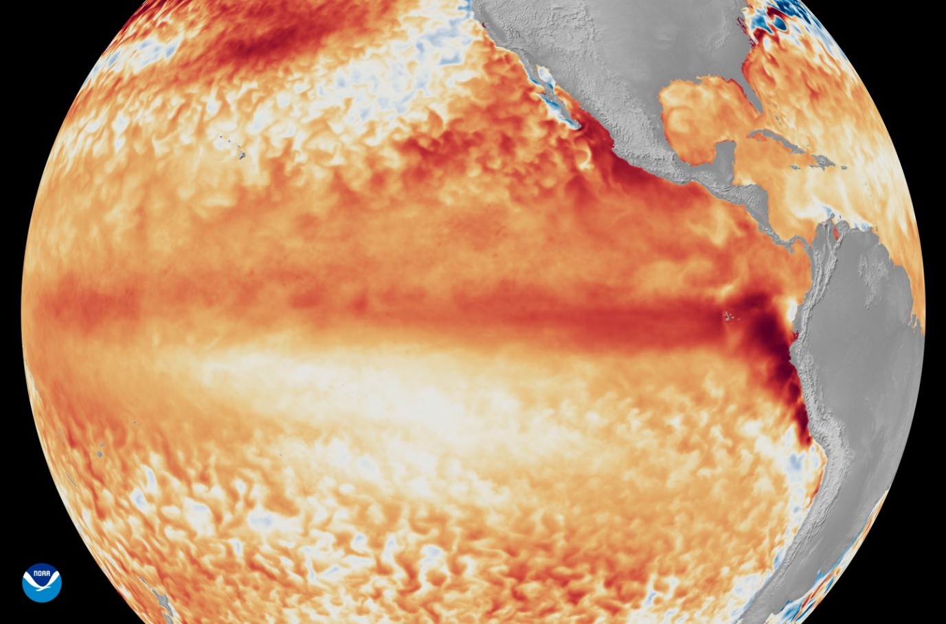
Satellite imagery from the first week of June 2026 shows that sea surface temperatures in the tropical Pacific Ocean are rising above the long-term average. Source: NOAA Satellites.
For investors, the significance of El Niño might not be just the event itself, but the vulnerabilities revealed. El Niño impacts can include extreme shifts in rainfall and drought conditions across key economies and increased extreme weather events, including cyclones and wildfires. Historically, these events pressure agricultural output, supply chains, and energy systems, causing substantial economic costs.
The economic impact of El Niño has been historically large. The 1982-83 event led to $4.1 trillion in global income losses, and the 1997-98 event cut global income by $5.7 trillion. But what makes the 2026 situation particularly important is that we’re already living in a significantly warmer climate than the 1982, 1997 and 2014 events.
El Niño acts as a stress test for global systems – disrupting weather patterns, amplifying physical risks, and exposing vulnerabilities across regions and sectors.
For investors, this El Niño might give us a glimpse of future climate change impacts that could regularly occur in the 2030s.
Get email updates about new ACCR research and shareholder advocacy on specific topics of interest to you.
Sign Up